In my previous blog post, I wrote about the relationships between people, policy, and materiality that make catastrophic landslides possible in Teziutlán, Mexico. In this second entry, I want to explore how the development of a landslide early warning system by National Autonomous University of Mexico researchers and National Center for Disaster Prevention engineers becomes a site where humans and non-humans become increasingly interconnected in the making of disaster mitigation techno-science. While doing this, I want to pay particular attention to those arrangements among people and between people that materiality engineers and researchers envision as optimal and those that are feasible in the context of contemporary Mexico.
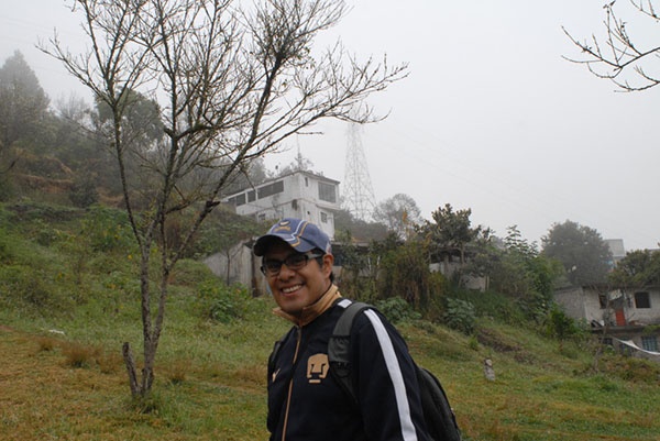
My friend and colleague, Felipe Juarez, at the foot of the Aurora landslide in February 2014. The CENAPRED monitoring station is located in the house behind (photograph by Roberto Barrios)
In late February 2014, I traveled to Teziutlán with Felipe Juarez, a Ph.D. student from the department of Geography at UNAM to check on the university’s water pressure and soil movement monitoring station, which the department manages jointly with CENAPRED technicians. The stations feature electronic equipment that sends wireless signals to the local emergency management station, which then relays these signals to UNAM’s offices in Mexico City.
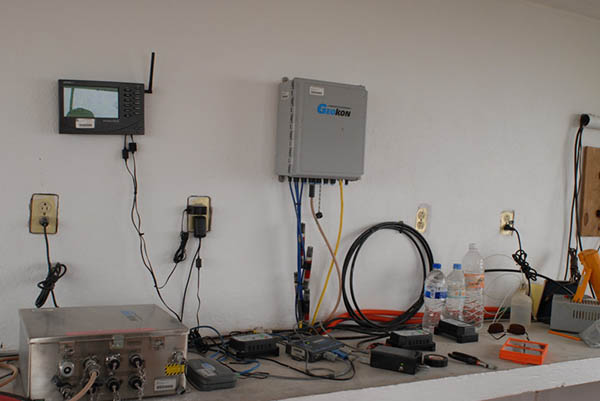
Precipitation, water pressure, and soil water saturation monitoring equipment (photograph by Roberto Barrios)
This web of data transmission is not a given and it is not guaranteed in state or national law. It is the product of carefully maintained relationships between local officials, academics, and state-employed engineers, the latter insuring that the former are willing to make their offices and computer equipment available to transmit the signals and troubleshoot equipment from time to time. On this occasion, we were lucky to coincide with CENAPRED technicians who traveled to Teziutlán to install a new repeater antenna. Recent construction in Teziutlán had blocked the signal from one of the monitoring stations to the offices of local emergency management and they were trying to find a new route to channel the “real time” signal to Mexico City. To make matters more complex, local government had just changed hands between the PRI and PAN parties, and a new director of municipal emergency management has just been appointed (as a reward for assisting the winning candidate with telecommunications over the course of the recent election) by the newly elected municipal president. Support for the monitoring stations (i.e. signal transmission, police protection of monitoring equipment) is not a guarantee, and after every election, local emergency management, CENAPRED, and UNAM academics must convince newly appointed directors of the station’s worth and the importance of continued collaboration. As Octavio guided us to the monitoring station, he made a call to the new emergency management director, inviting him for a tour of the station.
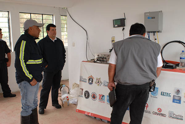
CENAPRED engineer Leobardo Martinez (far left) and Octavio Salazar (center) give the incoming Director of Emergency Management a tour of the monitoring station and impress upon him the importance of his office’s continued support for the project (photograph by Roberto Barrios)
When we arrived, CENAPRED technicians were already busy, checking wire connections between their tensiometers and pedometers that measure soil water saturation and water pressure across the Aurora hillside. As he checked on the equipment, CENAPRED’s chief engineer informed me that the station only collected information from three locations where sensors were installed in the hillside and that many more would be needed to know how the entirety of the terrain reacts to rainfall in the area. Nevertheless, budgeting constraints imposed by the federal government kept their knowledge of the hillside partial.
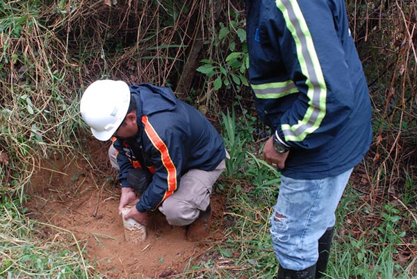
CENAPRED technicians check their soil water saturation monitoring equipment, one of three such data collection points on the Aurora hillside (photograph by Roberto Barrios)
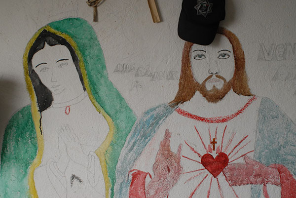
Teziutlán police officers have adorned CENAPRED’s monitoring station with religious iconography, proliferating semiotic connections between people and materiality in the making of technoscientific knowledge about landslides (photograph by Roberto Barrios)
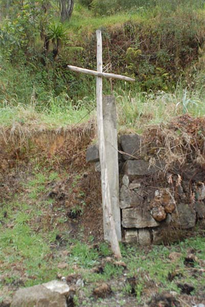
Teziutlán police officers have placed a makeshift cross adjacent to the CENAPRED’s monitoring station and on the edge of the 1999 landslide. In 2013, similar crosses were erected by landslide survivors in the neighboring state of Veracruz to implore divine forces to hold the land still (photograph by Roberto Barrios)
As we toured the station with the new director of emergency management, CENAPRED technicians also pointed out spots where local inhabitants had disturbed monitoring equipment during their daily activities (moving or removing data-transmitting wires), affecting their information-gathering process. Difficult socio-economic conditions for Aurora residents also mean that the station’s monitoring equipment needs 24 hour observation on the part of local police. The sale of stolen copper, batteries, and solar panels can provide a much-needed source of revenue for marginalized families. The police officers posted at the station have also become a part of it, painting religious imagery on its walls and planting crosses that implore divine powers to keep the soil from releasing into a landslide.
The case of landslide monitoring systems in Teziutlan illustrates important differences between the Mexico Ideal (to borrow a term from Guillermo Bonfil Batalla) and the Mexico Existente – the actually existing Mexico – of techno-scientific disaster mitigation researchers and specialists. The former is one where disaster researchers are provided with ample funding to obtain all the monitoring equipment necessary to document water pressures and soil movements in Aurora, where economic development projects include urban planning initiatives that insure residential spaces for working classes that are affected by minimal disaster hazards, and governance practices that allow for continuity in emergency management directorships from one administration to another, rather than the use of these positions as political rewards for campaign contributors. The latter is Teziutlan’s landslide mitigation efforts as they stand today, where community relocation projects cease to be viable places to live as they distance residents from services and places of employment, where politicized budget decisions come to bear on techno-scientific knowledge shaping how landslide-prone hillsides can be known, and where the collaboration between political appointees, researchers, and CENAPRED technicians involves careful balancing acts to insure continued support on the part of local authorities. For local experts like Octavio Salazar, the Mexico Existente of Teziutlán is falling short of mitigating landslide risk.
Acknowledgements: Thanks to Dr. Irasema Alcántara Ayala and UNAM’s Geography Department for supporting this ongoing ethnographic project.

1 Comment
Spot on with this write-up, I absolutely believe that this site needs far more attention. I’ll probably be returning to see more, thanks for the advice!