The Lao People’s Democratic Republic (Laos) does not have postal codes, street addresses, or mail delivery. Streets rarely have codified names. Since I started doing fieldwork in Laos in 2012, I have been fascinated by the ingenious maps that people make to navigate a country without codes. Every day, people make-do by making their own maps. Map making technologies (like GPS, digital mapping software, graph paper) are also important tools for my informants in the bomb clearance sector, where I do much of my fieldwork. Here, as well, people learn to make do by making their own maps. The present writing, however, is the first time that I have consciously tried to chart the source of my fascination.
My purpose here is to guide you through my own thinking on map making in Laos. By juxtaposing small stories, my goal is to replicate my own process of drawing connections between events recorded in my field notes, without trying to turn these connections into complete statements. I want to replicate the feeling of re-reading field notes in the field, and realizing something new but still a little unthinkable. You know the feeling I mean: the feeling of not really knowing where you are.
I live at hom see yoo Ban Simuang (small street number four in Simuang Village). I provide directions like this: I draw a little pagoda for Simuang temple and then count the small streets one, two, three and then four. My apartment is near the drainage culvert, the expat minimart, the gas station, the iPhone shop, the bus station, the Vietnamese pheu shop, the Academy of Social Sciences, and the French clinic. A friend of mine also lives on hom see. She has a screen shot of the Google Maps image of her house, which she shares with visitors:
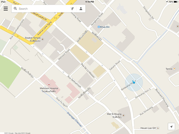
Map of apartment in Ban Simuang, Vientiane.
(c) 2014 Google – Map Data (c) 2014 Google
When I first stated fieldwork, Google Maps was pretty much inoperable in Laos: Even the capital city was mostly uncharted. By contrast, Google Maps began recording street views in Laos this July. The first Street View car visit made front page news: Google Street View Introduces Laos to the World (Southivongnorath, Vientiane Times 7/24/14). In particular, the city’s newspaper politely reminded citizens to clean up the fronts of their houses and streets so that the online world would have a good first impression of Laos. The author also cautions, quite pointedly, that the Lao government is in cooperation with Google to protect the privacy of its citizens and country on camera.
The newspaper article also teaches us how to enter the new map of the city. The article advises readers on how to find directions, and how to move the pegman to see different street views along a route (Southivongnorath, Vientiane Times 7/24/14). Walking with the pegman down an image of a Vientiane street, Google Street View becomes a version of Lewis Carroll’s Grand Map, a map built in a one-to-one ratio with the world:
“’We actually made a map of the country, on the scale of a mile to a mile!’
‘Have you used it much?’ I inquired.
‘It has never been spread out, yet,’ said Mein Herr: ‘the farmers objected: they said it would cover the whole country, and shut out the sunlight! So we now use the country itself, as its own map, and I assure you it does nearly as well.’” (Carroll 1889:No page numbers)
The new Vientiane map may herald a new city, open to digital visitors as well as locals. But despite these recent improvements, digital map abilities remain very limited in Laos. Even in major cities, it is often necessary to provide latitude and longitude coordinates in order to locate buildings in digital map systems such as Google Maps. And though digital maps may acquire a greater presence in Laos, it is still far easier to use the handmade maps that people draw on slips of trash paper, print on the backs of their business cards, or attach to their email correspondence.
***
I keep these other maps in mind as I think through my field notes from visits to UXO clearance sites. UXO stands for unexploded ordnance—bombs, landmines and other explosive ordnance left over from the Indochina Wars. Recording only the ordnance dropped by the United States during (what we call) the Vietnam War, Laos is among the most bombed countries in the world. The US dropped one ton of bombs for each person then living in the country (Boddington and Chanthavongsa 2009). Explosive power is sometimes recorded relative to the bomb: by this calculus, I could represent the American bombs dropped on Laos as one hundred times the explosive power of the bomb dropped on Nagasaki. I write in terms of the American bombs because only ordnance data from the United States has been made available to the public. Nearly a half century after the war began, more than half of the country remains heavily contaminated with unexploded ordnance (Boddington and Chanthavongsa 2009). Mapping is a significant part of how people manage living with bombs.
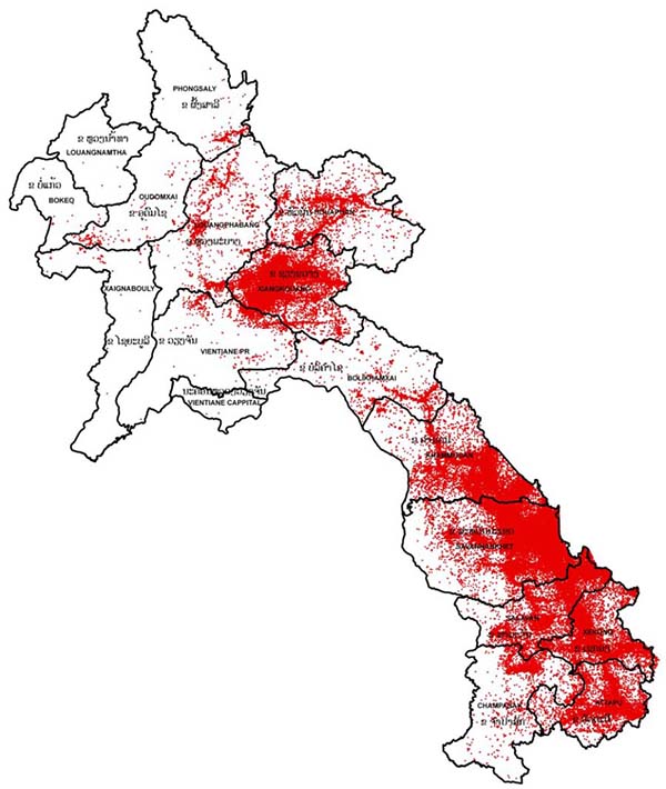
US bombing data map used to predict UXO contamination, National Regulatory Authority for UXO/Mine Action Sector Lao PDR (http://www.nra.gov.la/uxomap.html)
As per national standards for bomb clearance, clearance operators conduct community mapping activities prior to beginning clearance. Due to the surfeit of ordnance data, and the intervening decades, it can be extremely difficult to predict where bombs are going to be. The challenges of clearance are compounded by the lack of village-level maps. Community liaison officers work with villagers to create village-level maps and then to map the risks in a given area. For example, when villagers identify a bomb in their village, community liaison officers record the bomb’s GPS coordinates. In addition to reviewing community reports and maps from several clearance sites in Khammouane and Xieng Khouang Provinces, I also accompanied community liaison officers to a village map-making.
The meeting occurred in an old Soviet-era cinema, converted into a village meeting house. A small projector room in the rear, and a gently sloping floor, keep the building’s prior use in mind. Located betwixt two rice fields, the cinema appears both out of place and perfectly placed. The building references a past era of socialist reform, when, I imagine, cinemas and rice fields did go hand in hand. Each household sends a representative to the village map-making. About forty people attend, representing a village of about 150 residents. There are a handful of community liaison officers present, all Lao who grew up in contaminated villages in the area. At other times, each of them may have attended such meetings as villagers in their home villages.
Residents are split into different groups: the leaders’ group, the women’s group, the youth group, and so on. Groups are supplied with several sheets of poster paper (appropriately, recycled Mine Risk Education posters showing people what bombs look like). Each group is instructed to begin their maps by drawing the river or other major natural landmark. Then the village borders. Then the Naiban’s (chief’s) house. And so on down the scale, until at last one draws the tiny phi (spirit) houses. These last are especially important because clearance operators have to be careful not to disturb local spirits—if spirits are made angry, they might set off a lethal bomb explosion.
Once the community maps are completed, villagers are instructed to mark areas where UXO accidents have occurred and where bombs have been found. One thing I found particularly interesting while looking at maps produced at this and other meetings is how different groups make different maps of war waste. Overtime, clearance teams began to realize that different kinds of people were having different experiences of war waste—and this ad hoc social knowledge has been incorporated into their map-making efforts. In general, the youth group draws the most yellow and red dots (accidents and bomb sightings), since they are most likely to play in the fields and forests where bombs are common. The leaders’ map, by comparison, tends to record only accident sites, since it is their job to notify the district authorities of UXO survivors that may require medical and rehabilitation assistance.
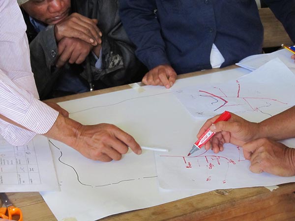
The leaders’ group draws their map of UXO contamination in their village in Xieng Khouang Province (Photo by: Leah Zani).
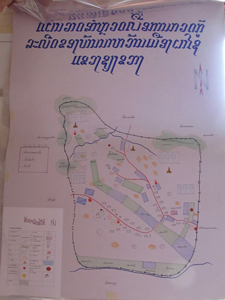
To a great extent, people already know how to draw maps. The community liaisons do not have to do very much facilitating. At the village meeting that I attended, there were small confusions over what the school/post office symbol was (a mailbox, totally alien to these upland rural villagers). Needless to say, their village didn’t have a post office. But in general, map literacy is quiet high. These are maps that people can draw themselves and that others can understand.
Originally, these maps were used to produce the field maps for clearance crews: all the community maps were collected and compared, and then clearance staff compiled a final, hand-drawn map. Individual clearance teams then may hand draw their own copies for use in the field. At the provincial office, layers of plastic are added on top of the original map to mark the work of different teams and targets. At one particular clearance office, I recall that these layered maps were displayed very proudly on every wall. The maps were sources of nostalgia for staff, reminders of successful clearance operations. These maps have clear kinship to the village maps, and were drawn by staff that may themselves have grown up in contaminated villages. They were drawn out of the same make-do map-making ability, and were thus understandable by non-experts.
Finished clearance maps displayed at the offices of a clearance operator working in Xieng Khouang Province (Photo by: Leah Zani).
In recent years, however, clearance operators have transitioned to digital maps. Under increasing pressure from donors and the Lao government, clearance operators are working to standardize their map-making practices. Digital maps are only half the solution, because digital maps are extremely unwieldy to use in contexts without printers, electricity, internet, etc. So, facing the same gap I introduced at the beginning of this post (the gap between mapping technologies and people’s everyday map-making), clearance operators are learning to draw as if they are digital map-makers:
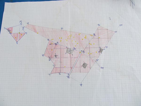
A hand drawn version of a digital map produced at a clearance site in Khammouane Province. Red areas are clear, white areas are unclear. Yellow dots represent bombs found. The gray rectangles are houses (Photo by: Leah Zani).
I find this recursivity fascinating. People are re-training themselves to see maps and territory differently by working on clearance teams that travel between provincial offices (digital maps) and field sites (hand-drawn maps). Unlike the villager-generated maps, these new kinds of maps require specialized expertise. For me, these maps possess a wonderful kind of incomprehension: they really don’t make any intuitive sense. Referents have been almost completely erased: houses are reduced to undifferentiated gray rectangles, there are no roads or other landmarks. Only the compass arrow North appears to have an existence outside the bounds of the map. These maps appear like Plato’s pure forms, geometric bodies suspended in space.
These maps provoke an even more fascinating kind of recursivity when they are replicated on the ground. Due to the lack of appropriate digital infrastructures (like electricity), I have never seen clearance operators take a digital map to a field site. But they do one better: Staked out with color-coded poles and twine, the clearance site is a one-to-one replica of the digital map in the database back at the provincial office. The ten by ten meter squares represented on the map are painstakingly replicated in full scale at the field site. People can walk through this map, and occupy it as if they are walking through the clearly marked zones of the maps. During clearance operations, for example, only one person is allowed to occupy one square at a time. It is as if the digital lines on the map are meant to mimic the straight lines of string pulled taut between stakes on the ground.
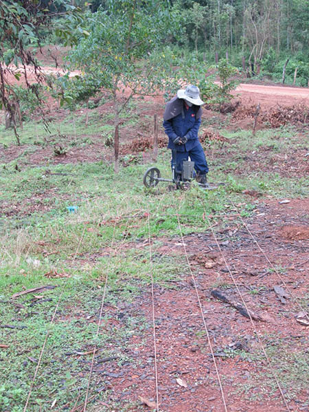
A bomb clearance technician carries out clearance in Khammouane Province. Each technician must stay within the lines marked with twine and stakes on the ground (Photo by: Leah Zani).
It can be extremely difficult to replicate these digital maps at some clearance sites. Once site I visited was in an uncultivated forest replete with trees, vines, and large rocks. Deeming it too contaminated to clear on their own, the locals had abandoned this site to the bombs and the vegetation. The clearance team leader complained to me that they were having trouble carrying out their clearance operations because they couldn’t get the lines straight. The team was finding it difficult to create a one-to-one map of the territory upon the territory. Going over my field notes from this site visit, I am forcefully reminded of Borges literary forgery on the science of map making. I’ll leave you with Borges’ wonderful story for your contemplation:
On Exactitude in Science
…In that Empire, the Art of Cartography attained such Perfection that the map of a single Province occupied the entirety of a City, and the map of the Empire, the entirety of a Province. In time, those Unconscionable Maps no longer satisfied, and the Cartographers Guild struck a Map of the Empire whose size was that of the Empire, and which coincided point for point with it. The following Generations, who were not so fond of the Study of Cartography as their Forebears had been, saw that that vast Map was Useless, and not without some Pitilessness was it, that they delivered it up to the Inclemencies of Sun and Winters. In the Deserts of the West, still today, there are Tattered Ruins of that Map, inhabited by Animals and Beggars; in all the Land there is no other Relic of the Disciplines of Geography.
–Suárez Miranda. Viajes de varones prudentes. Libro IV, Cap. XLV, Lérida, 1658 (Borges 1998:325).
Bibliography
Boddington, Michael A. B. and Bountao Chanthavongsa. 2009. National Survey of UXO Victims and Accidents: Phase 1. Vientiane: National Regulatory Authority for UXO/Mine Action Sector in Lao PDR.
Borges, J.L. 1998. On Exactitude in Science. In, Jorges Luis Borges, Collected Fictions. Trans. Hurley, H. Penguin Books.
Carroll, Lewis. 1889 [2014]. The Complete Sylvie and Bruno Stories With Their Original Illustrations. Reproduced by e-artnow.
Southivongnorath, Souknilundon. Google Street View Introduces Laos to the World. Newspaper article. Vientiane Times. 7/24/2014.

2 Comments
This is great. Thank you Leah.
Thanks for the work, I visited Laos a couple years back and can appreciate the difficulty in the task at hand.
1 Trackback