This post is the second in a two-part series on water management in New Orleans. Read part one here.
By adapting our city to our natural environment and the risks of climate change, we can create opportunities for all New Orleanians to thrive.
– From Resilient New Orleans (2015: 4)
“The Gentilly Resilience District will be a model for how other neighborhoods in New Orleans, across the region, and across the country, can adapt to thrive in a changing environment,” Derek reads aloud. A fellow with the Rockefeller Foundations 100 Resilient Cities, he explains to me the vital role the Urban Water Plan plays in the Resilient New Orleans initiative. Derek was trained in Urban Planning, and describes himself as an “ethnography sympathizer.” He had offered to take me on a tour of the Gentilly Resilience District, a model city space for the application of Urban Water Plan designs and community engagement. We hop in the city truck with New Orleans Redevelopment Authority (NORA) painted on the side and headed out.
Our first stop was the London Avenue Canal memorial garden, where a local nonprofit, levees.org, had commemorated the site of the flood wall breach and levee failure during Hurricane Katrina in 2005. A map of the U.S. Army Corps Federal Levee System breaches is captioned by an indictment of their planning and preparedness: “The London Avenue Canal was Destined to Fail.” The high walls blocking access and visibility to the canal seem to simultaneously serve as a way to hide the pending threat of the water, while also alluding to its inevitability.
In 2016, the US Department of Housing and Urban Development (HUD) National Disaster Resilience Competition awarded the city $141.3 million to implement the Greater New Orleans Urban Water Plan in the neighborhood district of Gentilly, requiring that 80 percent of the people impacted by the project fall under lower middle income levels (LMI). The designation of the Gentilly Resilience District offers a laboratory for urban development where water management strategies can be tested. Communities in Gentilly, once devastated by the surge of the London Avenue Canal during Hurricane Katrina, are encouraged to participate in monitoring and assessing environmental risk.
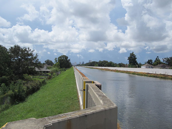
London Avenue Canal in New Orleans. Photo by Sean Mallin.
The Greater New Orleans Urban Water Plan is touted by city officials and architects as a “vision for long term urban water management in the 21st century,” and is the first regional plan of its kind in the United States.[1] As mentioned in the first post of this series, the Urban Water Plan attempts to reintegrate water into the city not only through material infrastructure but also through community inhabitance of the New Orleans landscape. With the recent municipal “resilience strategies,” the UWP represents a way to renegotiate the relationships residents have to the water — that for so long were marked by destruction. Through practices of citizen science and water based recreation the work of the UWP could turn water “from a threat into an asset.”[2] The relationship between citizen and waterscape thus becomes the mode through which community resilience is evaluated.[3] In this post, I will explore the urban water initiative through a tour of the Gentilly Resilience District that depicts how ambivalence toward municipal interventions, as well as to the water itself, reconfigures notions of citizenship and labor through environmental and economic risk.
Outfall Visibility
Much of the city’s water flows behind walls and through culverts, where residents rarely see it. The hope of the urban water plan is to create spaces where residents can regularly encounter the surrounding water, learn about how it shapes the city, and explore ways to manage its presence. Part of this plan is to take down high flood walls blocking the outfall canals, allowing access to the waterways so that residents can “gain a new perspective on the city” that will engender relationships between neighborhoods long divided by canal walls.[4]
Derek discusses how the canals hold potential for recreational and education spaces: “the goal of opening these up is to let communities be able to experientially learn about the water through recreation. Schools can use them to teach students about the city’s ecology and help the next generation become interested in water management. Not to mention, it’ll beautify the city.” The commitment to openness and visibility offers a way for residents to see their neighborhoods differently, but also serves as a way to recruit them as investors in city governance through the inhabitance of the waterscape. Cultivating a relationship to the water is thus a way of rendering participatory citizenship visible—allowing some to opt in and others to fall out.
As we drive away, Derek points out the new construction projects nearby: one, a prestigious charter school and the other, a juvenile detention center—both of which, he mentions, could use the canal for experiential education. In that moment, I recall a recent conversation I had with Tyrique, a Gentilly resident who lives and works just beyond the detention center campus. “What do you know about the urban water plan initiatives in the neighborhood?”
Tyrique responded, “never heard of it.”
Vigilance as Asset
Adapting to thrive, the rhetoric for one of the city’s resilience initiatives, asserts that opportunity for jobs and training in “the growing water management economy go towards those residents who need them most, particularly jobless African-American males.”[5]
Derek and I pull into the dirt road leading to the site of the Mirabeau Garden, the 25-acre “crown jewel” of the Gentilly Resilience District. This “Blue-Green Parkland” will be designed with natural landscape features to infiltrate water into the soil to slow land subsidence and to improve water quality. It is heralded as a project that will offer a neighborhood recreation space and that will act as an “environmental classroom” for schools and the general public to learn about water management design.[6] Donated by a former convent that was destroyed after heavy flooding, the Mirabeau Garden is intended to encourage the interest and knowledge about water management, which can be essential to the resilience of New Orleans’ communities.
We are met by a man driving a lawn tractor, who parks right next to the truck. He pulls off his cap and bandana and starts to yank on his utility gloves but pauses, “hello. I don’t think you are supposed to be here.”
Derek quickly responds “Hi, I’m Derek. We are with the city,” and extends his hand.
“Gregory. I am the groundskeeper on this land. Been taking care of it for years now. What can I do for you?”
“This land is a city project now, so we are just taking a little look,” Derek continues with a very pleasant smile. It was clear that Gregory finds our exploration of the to-be-garden suspect. This tension continues for a few more rather careful exchanges before Gregory begins to explain to us what the land is intended to become.
“The plans for here is a garden of some sort. A place for the neighborhood to use and they say it will be helpful for when it floods.”
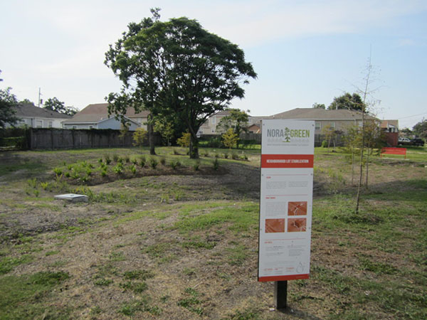
Vacant lot turned into a rain garden in Gentilly. Photo by Sean Mallin.
Derek is excited by this and starts to reiterate that it is a city initiative, “The city is putting in this garden to teach and demonstrate ways we can better manage water.” Sitting in the NORA truck as Gregory and Derek exchange seemingly parallel assessments of the land use, I began to see the somewhat mutual suspicion evolve into a discursive tug of war over who is responsible for the maintenance and monitoring of the space. Derek tows the line between asserting the role of the city and encouraging Gregory as a community stakeholder in the city’s resilience. Gregory’s vigilance operates as combative engagement with municipal intervention, but is also considered a managerial skill that could be an asset to the city initiative.
The implementation of the Urban Water Plan identifies infrastructural threats and redesigns them into accessible assets, yet it also reframes citizen participation as projects of vigilance that render economic and political stakes visible.
Gregory’s tone as we were about to pull away shifts. He removes his gloves and holds out his hand, “Do you think the city would hire me to continue tending to this land here?”
Derek reaches into his wallet and hands Gregory a business card.
The city’s pilot attempt in the Gentilly Resilience District will offer material visibility and access to the water but also seeks to mobilize citizen vigilance. As urban waterways are transformed from potential threats into community assets, are citizens too being responsibilized—that is, made responsible in certain ways—to inhabit their own neighborhoods through assessment of risk and opportunity?
Endnotes
[1] The Greater New Orleans Water Plan pamphlet, http://gnoinc.org/wp-content/uploads/GNOH2O_Pamphlet_Trimmed_FINAL.pdf (PDF).
[2] NDRC Competition Proposal (2015: 4).
[3] According to Mayor Mitch Landrieu, the resilience of New Orleans hinges on “striking a balance between human needs and the environment that surrounds us while also combating the chronic stresses of violence, poverty, and inequality.” Quoted from Resilient New Orleans (2015: 2).
[4] The Greater New Orleans Urban Water Plan (2013: 111).
[5] NDRC Competition Proposal (2015: 42).
[6] NDRC Competition Proposal (2015: 43).
References
2015 City of New Orleans NDRC-Phase 2 Proposal: Exhibit A-Executive Summary.
2015 City of New Orleans. Resilient New Orleans: Strategic Actions to Shape Our Future City.
Waggonner & Ball Architects. 2013. Greater New Orleans Urban Water Plan.
