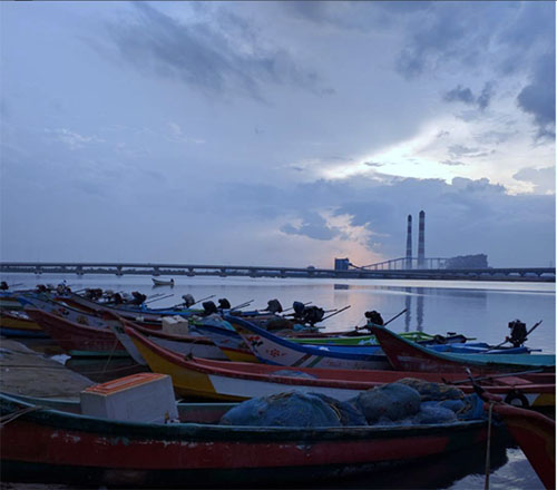
It was 8am in Ennore, a coastal region at the northern-most tip of the city of Chennai and home to artisanal fishers who have traditionally lived along the shores of the Bay of Bengal. I had recently started my fieldwork on property relations at coastal spaces around Chennai there. The sun was out, the fishers were busy sorting through the catch of the day, and the smoke from the factories around made everything look hazy. My neighbor and long-time Ennore resident, Kumar uncle, decided to introduce me to fishers he knew at Periyakuppam, a fishing village in the area. We met the fishers and as we stood facing the sea, I asked them about the history of the village and changes in the landscape over time. In response, they pointed at the sea and said, “Look! Do you see the sand there, the sea water extended till that point until last week, but it has receded further now…come again next month and see what we’re talking about!” Just a few minutes later, they shifted their gaze to the left and asked, “Can you see those ships in the distance? That is where the port is. They built it for the ships bringing coal to the power plant. They put in sea-walls around there…” and once again, shifting their gaze towards the shore and the sea they said, “Look there, half the land in that village is now under water; it’s because of those stones from the sea-walls over there.”
Staying in place in times of flux
How do people read, sense, and narrate landscapes through metaphors of liminality, flux, or fixity? What work do metaphors of fluidity, flux and fixity do in contexts where the coast is profoundly “natural” and “infrastructural” at once? Coastlines have become important spaces where the effects of both slow and fast disaster (rising sea levels and gradual erosion, cyclones and floods) are most palpable. Environmental activists in Chennai have focused on the ways in which climate change and rising sea levels threaten to disrupt life as we know it. They have argued that coastal regions act as conduits for flood water to flow into the sea, protecting the city from flooding when sea levels rise. Activists have drawn connections between climate change, coastal sea level rise and the future of coastal cities. Seen from the perspective of such narratives of disruption, dwelling, building and indeed life on the coast is immensely risky business.
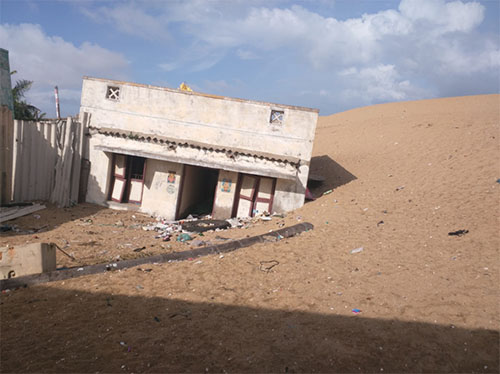
Yet, fishers in Chennai adamantly stay on, at spaces that could be washed away by the sea in a few years. At many of the fishing villages in Ennore, I usually began my day by asking questions about boundaries. Were the houses of fishers always so close to the sea? Was there more sand earlier? Fishermen recalled that the sea had moved further and further inland over the years. Entire temples had been engulfed by the sea water and were no longer visible. Typically, my conversations with them about the industries and sea level rise devolved into predictions about how their homes would be washed away in ten or fifteen or twenty years.
At one level, these narratives of disruption seemed to echo activist accounts of disruptive change. And yet their immediate responses to such perceived disruption were often very different. ‘Where would you live and what would you do if your houses got washed away?’, I asked my interlocutors. Their answers varied: sometimes they laughed, sometimes they shrugged my questions away. At times they responded with anger that their imminent displacement was thinkable and a subject of casual enquiry. When they did engage, the fishers described their homes in relation to sea-walls that would work to keep the sea at bay. While pointing at erosion at some parts of the coastline, they also noted the accretion of land at others. Thus, it seemed to them that those sea-walls near the port caused erosion along Ennore’s coastline, whereas these sea-walls near the estuary had kept the sea at bay and the shoreline had extended into the sea. Further, they argued that staying closer to the sea was necessary to be able to gauge the winds on each day or to save any struggling boats. In fact, given the changes in wave action due to sea walls, staying closer had become even more urgent! Notwithstanding the seeming riskiness of the coastal spaces at a planetary scale, place-specific histories of infrastructure and movements of water mattered. Ultimately, despite the narratives of flux in the distant future, there was no talk of moving away in the present or in the ‘near future’ (Guyer 2007).
Relative fluidity and continuity
What sustains these claims and struggles of fishers to dwell, live and play on the seemingly risky coast? Over the course of my fieldwork in Ennore, fishers often pointed out that there have always been smaller scale shifts in the boundaries between land and sea on the coast. In several cases, due to erosion, fishers belonging to one village had moved closer to a neighboring village and now share the beach with them. Fishers still remembered both the old and new boundaries of each village. They described these shifts in relation to the movements of the water as an ongoing process, and not as displacement or upheaval of their lives. Similarly, during periods of floods and disasters like tsunamis, fishers recalled moving to higher ground until the water receded. Older people also remembered times when they had had to leave Ennore to live with their kin elsewhere on the coastline until they could get back to their own village.
It would seem to us that these movements make the coast an inherently fluid landscape and particularly risky grounds to live on. However, fishers have experienced these everyday, seasonal, and sudden shifts in the boundaries of land and sea and in their place of dwelling as a form of continuity. A cosmological understanding of certain forms of change as continuity perhaps helps fishers make sense of their present as they make claims for a better future.
Divining Uncertain Nature-Cultures
Environmental activists working in Ennore have organized campaigns that gather evidence to hold specific industries or persons as legally culpable. This has entailed establishing cause and effect in terms legible in a court of law—the identification of human interventions as causal factors that exacerbate the threat of rising sea-levels and make for a risky coast. Fishers too have articulated broader sets of connections between the construction of a powerplant here to inundation of the land there. But there has been no consensus among fishers around the precise causal linkages that tie the sea, infrastructure and their everyday lives. For fishers, staying put at a seemingly risky coast makes sense given the longer histories of human interventions at the coast, which involves both continuous gradual change and a prospect of drastic change in the future.
Thinking with places like Ennore and its people, the quintessential challenge for our times is to make sense of the intertwining of both planetary climate change and large-scale infrastructural interventions. There are large amounts of opacity involved in comprehending the precise effects of each as well as the effects of their interaction. Just like our interlocutors, researchers of climate change are also suspended in the middle of processes that have always already been unfolding across varying temporal scales—over deep time, national time, infrastructural time, and so on. As such, fishers, environmentalists and researchers in their explanations of change and causality offer varying cosmologies to live with opacity and uncertainty of coastal infrastructural times.
References
Guyer, Jane I. “Prophecy and the near future: Thoughts on macroeconomic, evangelical, and punctuated time.” American Ethnologist 34, no. 3 (2007): 409-421.

1 Comment
The article of Oviya Govindan nicely captures how the fishing community at Ennore has come to term with the uncertainities of changing coastlines.
Is there any Government body or NGO which periodically records the boundaries of coastlines to draw links with sea tides, weather changes, infrastructures built, and global warming?
Is there a comparative study of another coast line where there is no impact of man-made structures such as sea-walls? Such a study would help us to interpret whether human activities such as sea-walls cause coastline changes.
It is a well written article. Now I understand why fisher families continue to live close to the shores, inspite of high risks.