In 2009, the Taiwan High Speed Railway Company (THSR) claimed that severe land subsidence in Changhua and Yunlin counties was compromising and damaging the structural integrity of the railway. The THSR urged the government to regulate the over-pumping of groundwater in the region, which was seen as culpable for the land subsidence, in order to guarantee the safety of the rail users. Since the agricultural wells constitute a significant proportion of the total wells in these two counties, the safety issue became an issue of “water-justice” – local farmers have accused the Sixth Naphtha Cracking Plant owned by the Formosa Plastic Corporation of exploiting Yunlin’s surface water thereby forcing them to pump groundwater. To tamper farmers’ sentiments, the central government announced that according to a relevant survey, land subsidence was caused by deep wells, rather than farmers’ shallow wells. Therefore, the government would not forbid the pumping of groundwater by farmers in Changhua and Yunlin county.
This event reveals the conditions of Taiwanese environmental governance. Even though farmers can disagree with the government’s interpretation of the environment, they cannot propose any discourses which are credible enough to contest the government’s statements about the underground world. The government gave a “scientific reason” to judge that the farmers are not responsible for land subsidence. However, this does not mean that the farmers lack knowledge or experience around groundwater or land subsidence. While the farmers may have their own set of embodied practices and experiential knowledge that they share with one another regarding groundwater and land, the government is able to dismiss this knowledge as merely personal experience, while denoting its own investigation as a more “whole” or scientific depiction of the underground world. This unequal power dynamic renders farmers’ voices and epistemologies as nothing but disagreement, resentment, or doubt towards the government’s judgement, foreclosing the possibility of a serious presentation of an alternative.
Today, at least in Taiwan, personal experience is not a legitimate way to make claims in public discussions around groundwater issues. Our governance, our environmentality, our self-discipline asks us to consider the “whole” picture. Why then is the Taiwanese government able to announce that they have a whole picture? Why can they assess and evaluate the risk of developing groundwater? Why are they the ones to identify the causes of land subsidence?
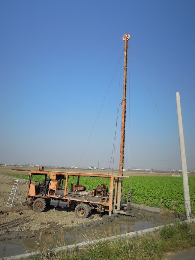
Large-scale geological surveys and the long-term environmental monitoring allow scientists and technocrats to feel that their statements about the groundwater are more credible than farmers’ personal experiences. However, groundwater cannot be observed directly – water that flows in the cracks of the sand, soil, rock which are unevenly dispersed throughout the underground world. To get information from the underground, one must drill a well into the subterranean world. To know the “whole picture” of groundwater, people need not only one well, but a “well network.” Since 1992, the Taiwanese government has spent more than 2 billion dollars and 30 years building a groundwater monitoring network (GMN) which includes more than 800 monitoring wells (to check the groundwater level) and 500 geological drilling wells (to get the geological survey samples). It is still expanding its scale today.
This blog post discusses how the GMN was built and why the Taiwanese government was willing to expend so many resources to build it. As mentioned, the GMN is not only an environmental monitoring system or a scientific project. The GMN is an infrastructure that makes it possible for the Taiwanese government to declare that it knows more about the underground world than normal people do. Thus, the GMN is also an infrastructure embedded in the unequal power dynamics of the environmental politics of the subterranean. Through examining the proposal, design, and building of the GMN, I hope to (1) complicate our understandings of what “monitoring” is and does; (2) question how we come to know the environment on a large scale; and (3) investigate how scientific surveys are deployed in determining what nature is and how we treat it.
A Brief History of Groundwater Monitoring in Taiwan
Before the GMN, there was an old groundwater monitoring system that was used in the 1950s-1980s. In the 1950s, due to food insecurity, the KMT government encouraged farmers to cultivate paddy rice. However, they soon discovered that although there was a large amount of arable land, the irrigation water was insufficient. Thus, the KMT government devoted itself to groundwater development. Considering severe land subsidence caused by the over-exploitation of groundwater in the US (e.g. California), American advisors to the KMT suggested that officials construct a monitoring system. If the monitoring data were to show that the water level had dropped severely, the government should prohibit groundwater pumping until the water level rises again to ensure the sustainable use of groundwater.
But things didn’t go as planned. To support large-scale groundwater exploitation, the KMT government borrowed money from the International Development Association (IDA). However, with strong competition from the private well drilling sector, the KMT government gradually became uninterested in exploiting groundwater by themselves. In 1976, the Ground Water Development Bureau, the only agency that responded to groundwater affairs, was abolished. Although the KMT government retained the monitoring system, data and device management worsened. While water resource officials noticed that groundwater levels had dropped severely and tried to ban water pumping in response, local governments challenged the reality of monitoring data in refusal of regulations. The local government officials maintained that the groundwater level fluctuates naturally according to the difference in seasonal precipitation, i.e. rain or dry seasons. However, the water levels in the monitoring wells did not reflect such seasonal patterns. Thus, they concluded that the monitoring wells were not connected to and representational of the conditions of any particular entire aquifer. Drawing on this problem, the local government officials asked the water management to not prohibit groundwater water pumping until they had more credible data. In short, the data produced by the old groundwater monitoring network couldn’t provide enough justification for groundwater regulation.
In 1979, Typhoon Hope hit the southern coast. The tidewater passed the sea dike and prompted water management officials to consider that the seashore might be sinking. However, they couldn’t get solid data to verify this speculation, until several huge typhoons passed through Taiwan in the following years, causing flooding to the seashore area. The official understanding of the cause of this sinking was subsequently labeled as “overpumping.”
In 1986, Chao Yao-Dung, the chair of Council for Economic Planning and Development, Executive Yuan (CEPD), left Taipei to inspect a dam in central Taiwan. Lin Young-De, an official of the Council of Agriculture (COA), took a chance to bring Chao to the western coast. According to Lin’s recollection, Chao was shocked by the landscape he saw – the sea level was higher than the inland, only separated by the dike. Soon after Chao came back to Taipei, he discussed the land subsidence issue with Lee Kuo-Ting, Board of Science and Technology of the Executive Yuan. Finally, they decided to invite a foreign specialist to Taiwan to investigate groundwater and land subsidence problems. In 1986, Dr. Thomas L. Holzer, a famous USGS hydrogeologist, was invited by the Taiwanese government. After two weeks of investigation, Holzer suggested that the government should build a comprehensive database and monitoring system for groundwater. His suggestion was accepted by the KMT government and the project was assigned to the Taiwan Provincial Water Resources Bureau. At the suggestion of foreign specialists and the upper echelons of the central government, the groundwater issue received vast focus and resources, launching a new generation of the GMN system.
GMN and The Birth of a New Underground World
The rebuilding of the GMN did not only add monitoring wells and renew monitoring devices. To the groundwater specialists who were recruited to the mission, the key issue was what kind of underground world they wanted to see. The main problem was that monitoring wells were drilled through different aquifers. Therefore, the first-generation GMN couldn’t discern the changing water levels from different aquifers. As a result, through the first-generation monitoring system, people could only see the changing water level of “one” groundwater reservoir, rather than multiple layered aquifers.
To a government that was only interested in exploiting water, this design wasn’t a big problem. But when regulation was contested, the government and specialists found that they didn’t know which aquifer should be monitored and what kinds of wells should be regulated. The monitoring infrastructure couldn’t give the government enough information in order to regulate, and the water resource management officials had to face huge political pressure from various groups of people that relied on groundwater for various purposes that they drew using different technologies from different aquifers.
The consideration of regulation brings forward new forms of discipline, new ways to survey, and a new way of seeing the underground world. The discourse around groundwater, and in particular the desire for ‘legitimate’ knowledge about the issue birthed a new form of ‘environmental governance.’ Assigned with implementing the GMN, the Taiwan Provincial Water Resources Bureau organized a “technical group” to assess and design the new system. The technical group included officials from the Taiwan Provincial Water Resources Bureau and Geological Survey in Taiwan, scholars of engineering, geology, hydrogeology, as well as well drilling specialists. To figure out the “major aquifer,” the thickest and the most extended underground water strata (that is, the most important aquifer to be regulated), hydrogeologists and engineering geologists asked for a new underground map that represented the depth, thickness, and length of the aquifer.
First, the hydrogeologists in the technical group introduced a new theory that presumes the formation of strata – and thus aquifers – is facilitated by the pattern of Earth’s long-term climate change. In other words, the new government project not only invokes geography, but also the history of the subterranean. To understand the formation of strata, hydrogeologists need biological samples such as foraminifera fossils and pollen as the key indicator for the age of the strata. However, since the purpose of groundwater development and monitoring in the 1950s-1970s was finding where water is, the investigators collected cheaper standard samples by “cutting” (broken rocks). These sampling and analyses were adequate to locate groundwater – accomplishing the goals of the 1950s. Ironically, the “cutting” method typically destroys the very data that the hydrologists in the 1980s sought after. Because the “cutting” method acquires its sample by pounding down at the ground surface with an iron tube and flushing out the underground strata with the mud (see photo), some thinner or softer layers of the strata and the bio-samples within them might be deformed and lost in the process. Moreover, well-sinkers had been responsible for sample coding, yet the specialists of the technical group doubted the well-sinkers ability to discern different kinds of samples. They also had professional geologists at least with undergraduate degrees code the samples. Hydrogeologists saw “coring” as a technical solution to the messiness of getting down into the mud to collect samples. However, by introducing and excluding different actants, the technical group reassembled a new underground world with history and geography. In the following section, I will detail how the socio-technical practices of coring are equally muddled and messy.
A machine pounds into the ground in order to collect strata samples as part of the cutting process. With this process, mud acts as a solution to help usher out the pieces of strata. (Photo Credit: Author)
After the mud is flushed out by cutting, a driller collects the samples from the mud. (Photo Credit: Author)
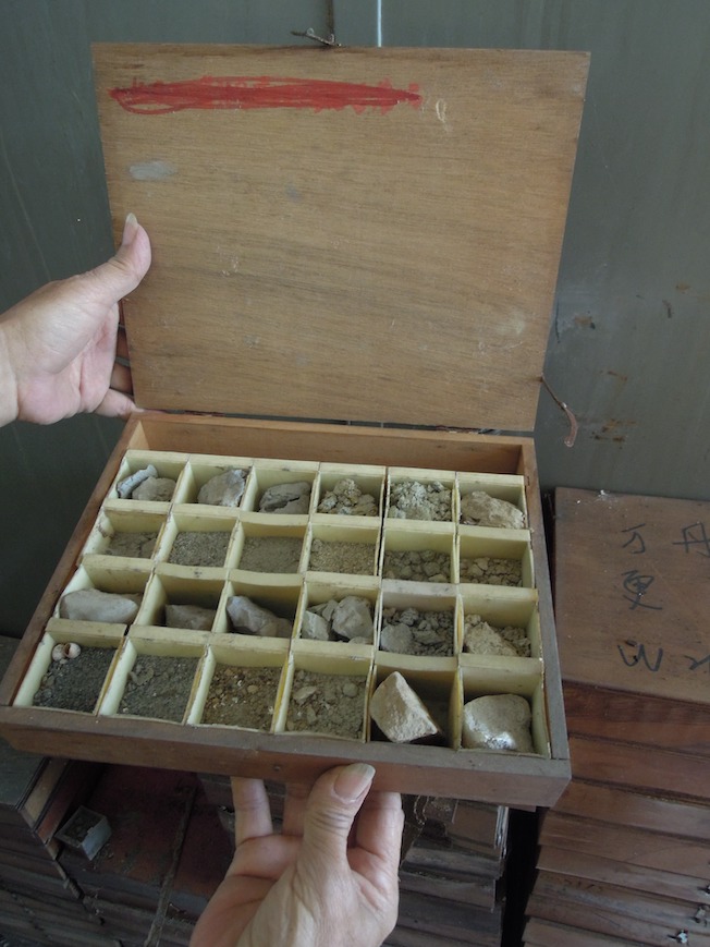
A box containing an assortment of samples obtained by “cutting” organized according to depth. (Photo Credit: Author)
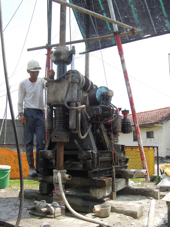
A drill being used to “core” and collect “core” samples. A metal tube will be drilled into the ground in order to extract a column of geological strata and sediment. (Photo Credit: Author)
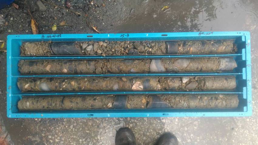
A collection of “cored” column sediment samples. (Photo Credit: Author)
Silent Technicians: Local Technical Networks
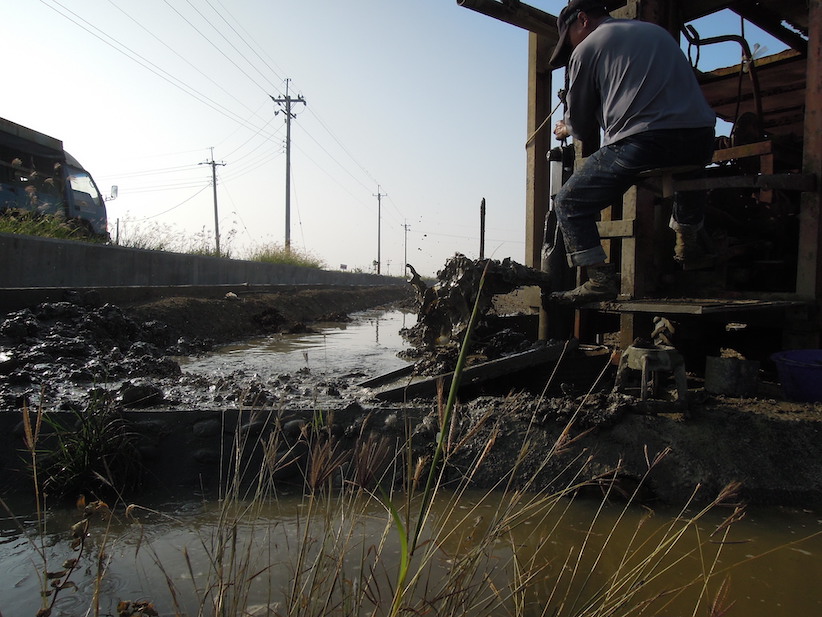
As this new underground world was re-visualized and a new monitoring infrastructure and corresponding mode of governmentality emerged, the technical group was met with a new challenge – how to collect enough credible core. After all, no officials, specialists, or geologists know how to get the core, so they still have to depend on a well-driller.
From my fieldwork on a groundwater survey project, I have come to realize that conducting hydrogeological research is not only a scientific endeavor but also an engineering process. To be more precise, hydrogeological scientists do not simply “observe” and “describe” the world “out there” mediated or represented by “natural/neutral samples.” Instead, the production of scientific data and knowledge is critically conditional upon and constituted by the idiosyncratic skills, practices, and motivations of the local technicians (i.e. drillers and blacksmiths). Theoretically, the “core” sample (acquired via the “coring” method) is a more “intact” sample that better resembles the underground strata more closely than the “cut” sample (acquired via the “cutting” method). However, the recovery rate and quality of the core sample largely depend on the technical competence of the individual well driller. For example, a skilled and experienced driller must master the art of balancing the amount of “mud” circulating in the drilling system. The handling of the “mud” is highly crucial yet tricky because the drilling system requires the presence of “enough mud” to prevent the collapsing of the well whereas “too much mud” will lower the recovery rate and quality of the core sample. The technical competence of the local well drillers to strike a “sweet spot,” which ensures the integrity of both the well and the sample when drilling in the field underpins (and/or undermines) the ability of the extra-local hydrogeologists to make scientific observations and claims in the lab. And yet, these critical processes and dynamics largely lie beyond the purview and control of the hydrogeologists.
In addition, some drillers might fake/fabricate part of the core samples when their recovery rate and quality are suboptimal and cannot meet the agreed-upon standards with the hydrogeologists. An official from the groundwater survey project told me that he once requested the whole drilling process to be redone because he detected traces of out-of-place “modern/contemporary fabrics” in the core samples taken from deep geological strata that are way too old/ancient to have contained them. And thus, the specialists and officials who are in charge of the GMN stress the importance to recruit local drillers who are both “skilled” and “honest” to operate for them.
Besides skill and personal character, another factor that affects drillers’ ability is the technology they employ. One driller told me, no one can anticipate what kinds of strata they will meet before they start drilling. Therefore, they often change or re-design the component of their machines to adapt to the underground environment. Yet they cannot do this by themselves. They have to ask the blacksmith factory to manufacture the desired components. The blacksmith factory can customize and reassemble a drilling machine and its components to meet the specific needs and requests of a driller.
Moreover, with time, GMN’s budget has been decreasing, yet the scope of groundwater monitoring is still increasing. As a result, less money is distributed to the drillers. To keep a stable profit rate, drillers prefer fixing and modifying their machines rather than buying new ones. For example, in the earlier years of the GMN research projects, the specialists and officials requested smaller core samples (i.e. samples that are shorter in diameter). Therefore, the drilling machines designed by the blacksmiths and used by the drillers were smaller in size. However, in the later years when the specialists and officials requested larger core samples (i.e. samples that are longer in diameter), the drillers worked together with the blacksmiths to modify and reassemble the original drilling machines into ones that can accommodate larger spindles to meet the new requirements of sample collection envisioned by the specialists and officials. This interplay makes such scientific-governing processes materially and technically possible and enactable. In other words, both the local drillers and blacksmiths have played an indispensable yet invisible role in the production of groundwater governmentality.
Conclusion
Returning to the issue of train traffic, why and how does the government acquire the ability to claim land subsidence as a key factor? The GMN plays an important role in establishing this legitimacy, which not only provides long term monitoring data but also a large-scale geological surveillance. The ability to build the GMN comes from an assemblage of different actants – scholars, officials, core, fossil, drillers, ironsmiths, etc. The GMN supports groundwater governmentality in Taiwan today and is a scientific-engineering-governance nexus. Considering the history of the first generation of GMN, this nexus should not be assumed to be permanent or even stable.
The survey and surveillance work done by the GMN produces and accumulates a huge scientific database of hydrogeological information and detailed references across space and time. The GMN database provides legitimacy and authority to the specialists and officials who claim to have a more accurate understanding of and effective solutions for the land subsidence problem. It also renders other claims unimportant and irrelevant – at least not in a “scientific” sense. A farmer’s “personal” observation at their own well doesn’t really matter if the GMN database has indicated and the specialist-official interpreters have decided that the groundwater levels are dropping in the Changhua and Yunlin region. The farmers’ voices only matter as an “agricultural constituency” or an “interest group” – in a socio-political or sectoral sense. These developments not only enhance the discursive and administrative powers of the specialist and officials but also buttress the nascent “database governmentality” or Rule of Big Data. Currently, the Taiwanese government is promoting the registration of privately-owned wells within the government database to better regulate the various groundwater usages in the Changhua and Yunlin region. In the face of the growing enterprise of an underground database, not only the farmers’ but also perhaps other “concerns” that are deemed as “non-scientific” will pale in significance vis-à-vis scientifically produced and established environmental facts and truth.
This post is part of the series “(Re)Assembling Asias through Science.” Read the series’ introduction and contact editors Chunyu Jo Ann Wang (chunyuw@stanford.edu) and Tim Quinn (quinnt@rice.edu) if you are interested in contributing!
