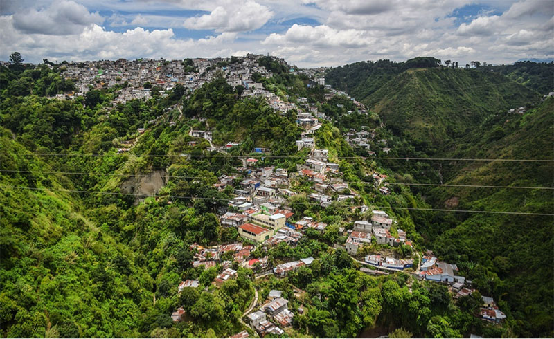
Deep, canyon-like ravines fracture forty-two percent of Guatemala City. Covered in thick, wet, and dense foliage, these ravines are contentious ecological forms for Guatemala City residents, who have often described ravines as physical borders that disconnect their city; opportunities for landfills that are out of sight, out of mind; informal housing for gangs, violence, and the city’s poorest[1]; as well as precarious locations where damage from earthquakes, floods, and landslides is felt the most. However, in 2006, the city municipality reclassified these ravines as an “ecological belt” (Cinturón Ecológico Metropolitano), identifying them as sites in need of ecological and developmental attention. Architects in particular have taken special interest in these ravines, arguing for sustainably-minded designs that would develop and connect ravines to the broader city landscape. Ravines, they argue, are underutilized and contaminated spaces that work against, rather than with, the built environment. Interested in the classification and production of space, in what follows, I describe the conditions that led architects to recognize ravines as sites of developmental potential in Guatemala City. In order to be designated as spaces for development, I argue that ravines first needed to be redefined volumetrically and epistemically, revealing new parameters for thinking about where the built environment can reside.
In 2008, Guatemala City implemented the very first land-use plan in the entire country. The plan, known as POT, or plan de ordenamiento territorial, literally and metaphorically placed ravines on the map. Through an algorithmic design, municipal urban planners designated any terrain that contained a slope of more than forty degrees as a site of special attention for ecological conservation. These terrains became formally recognized as ravines (barrancos). This method of defining ravines was influenced by the growing concern for the safety of those living within them. In response, the late Mayor Alvaro Arzú had implied that, with a land use plan that privileged sustainability, better attention could be given to the geographies that occupied nearly half of the city but were rarely engaged with at any formal level.[2] Thus, due to POT’s algorithmic design, ravines were given legal, topographical boundaries. This newfound attention to the topography of the city provided ravines with a new definition, one that emphasized their volume. From that point on, a ravine’s territory included not only the lateral, geological slopes of the ravines, but the vertical, three-dimensional space in between ravine plateaus and ravine crevices as well.
Subsequently, in 2010, a group of local Guatemalan architects banded together around an idea to utilize ravines as sites for major transformation and improvement of Guatemala City’s infrastructure. Together they created the collective Barranco Invertido (inverted ravine) as an organized effort to design the empty and vertical spaces of ravines into productive city sites. [3]When I spoke with architects about their visions for ravines, they often pointed out how each ravine’s unique shape produced different possibilities for design, emphasizing that each and every ravine was new and unique territory yet to be studied. In doing so, they argued that designing ravines would make the city more cohesive by assessing how to best utilize each ravine to suit the social and ecological needs of its local environment. Crucially, it would also distinguish Guatemala City from other developing cities throughout Latin America. Instead of being viewed as another underdeveloped Latin American city, Guatemala City could become a 21st-century site that displayed a sense of modernity through a careful implementation of sustainable design and idiosyncratic development. In other words, rather than being seen as a nameless, underdeveloped, and disorganized city—as Western assumptions of city capitals in the Global South often maintain—Guatemala City could begin to build an international reputation for itself by focusing on, emphasizing, and developing their ravines as distinctive topographies that represent Guatemala as a sustainable and modern society.
With and Against Verticality
When writing about the pursuit of modernity in postwar Latin America cities, Beatriz Jaguaribe argues that “Capital cities tend to exhibit a deliberate architectural symbology that distinguishes them from other cities. They symbolize the construction or the several constructions of a national pantheon” (1999: 326). Similarly so, the distinctive landscapes of ravines contain the potential to become unique and aesthetic sites that market Guatemala City as a place with geographic individuality and also as a city with international legibility in the broader context of urban planning, sustainable development, and social equality. These concerns for social equality greatly influence architects’ imaginations for ravines. If forty-two percent of Guatemala’s territory are deep, green crevices, then architects are interested in how the city could best utilize these vertical and negative spaces for social improvement while conserving their ecological diversity. To improve the city, architects first identified some ways in which ravines’ vertical and geological forms spark or maintain social inequalities. One architect pointed to an informal settlement at the bottom of the ravine, showing me how the poorest of Guatemala’s citizens live in the ravine depths while the wealthiest of city residents reside above on ravine plateaus. Ravines, he suggested, help support a physical and social hierarchy within the city. Anthropologists, too, have noted ravines as sites that highly influence social mobility in Guatemala City. As Kevin Lewis O’Neill and Benjamin Fogarty-Valenzuela have theorized, “For one, verticality marks yet another strategy by which elites abandon public space; lifting themselves above the poor, the marginalized, and the violent, they engage themselves or each other but not their fellow citizen below…Verticality stratifies society one layer atop another” (2017: 379). Cultural geographers have long noted how a vertical orientation can open up new insights into social dimensions and urban complexity (Battaglia 2012; Braun 2000; Harris 2015).
The architects of Barranco Invertido are tapping into a verticality other than the skyscrapers that increasingly define the city skyline. In designing the actual ravines with the vertical form of the city, architects argue that they are imbuing them with so-called “good-design.” Good design is a critical neologism for my interlocutors. It is loosely defined as the set of practices and techniques that best meets the intentions of any design project (Hayward 1998). Citing contemporary architectural movements such as Ecological Urbanisms (Mostafavi and Doherty 2016), the architects of Barranco Invertido are deeply committed to the relationship between social equality and sustainability in their design practices. Conservation for these architects is both ecological and cultural, where designing well with the environment (rather than building on top of the environment) could improve social equality in Guatemala City. Thus, architects trouble themselves with the question of how to bridge the city above with the city below, and with as little environmental impact as possible. As Esteban, an architect of Barranco Invertido, argued: “what if the city was the opposite? Instead of invisible slums, they would become a part of the everyday landscape.” The empty and steep space between ravine depths and ravine plateaus, in Esteban’s opinion, is what has been preventing the municipality from making any serious interventions in the social inequalities and toxicities that lay down below. While ideas for floating houses and public transportation are far-reaching goals, an ecological park named Jungla Urbana located in a middle-class neighborhood in Zone 15 and a bridge connecting a ravine’s great divide in a Zone 5 neighborhood known as Primero de Julio have been actualized.
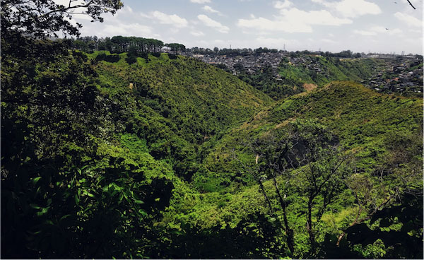
Photo by author: Ravine in Zone 3, Guatemala City
The Void Emerges
For architects, a ravine’s unique ecological form produces an immaterial space that is difficult to engage with on a planning level. Rather than utilize the physical slopes of the ravines, the floating space that resides between ravine plateaus is of interest for development. As sites with few to no boundaries, these free-floating spaces—or voids—are troubling to work with on a conceptual level. As Gastón Gordillo has argued, the negativity of a void actually holds a positive presence and “may be itself a kind of place,” a “scene of emergence (Casey 1997, 17, 19-20)” (cited in Gordillo, 2012: 57). Furthermore, notions of voids are “subsumed to those of place in the sense that the void is a place, but one that is ‘bereft of body’” (2012: 57). This absence of a material body not only troubles the modes of design that can exist in a floating space, but also blurs the types of spaces that can be designed and developed. If the empty space that ravines produce between their plateaus can be considered voids, and if voids are indeed places rather than non- or empty spaces, then the architects of Barranco Invertido are interested in bringing the built environment to a place “bereft of body.” In other terms, this attention to the unique space that ravines occupy, not solely their boundaries but the empty space produced in between their plateaus, transforms them into currently wasted space and a future opportunity to improve Guatemala City. Ravines thus immediately become wasted spaces in the built and developmental potential for Guatemala City only once they were considered to be places that had the potential to be planned in the very first place. Furthermore, a ravine’s verticality suggests a new conception of which spaces are buildable, as well as adding to what types of space can be wasted to begin with.[4]
Overall, the empty space that resides between ravine plateaus and ravine depths are previously unrecognized spaces for development. In the eyes of architects, it is precisely their underdevelopment that has been preventing a more unified Guatemala City. If so-called “good design” of ravines could alleviate social and environmental inequality by recognizing that the natural and social environment influence one another, then architects first needed to designate ravines as empty spaces in need of design in order to eliminate the problems that a ravine’s verticality creates. The empty space between ravine plateaus and ravine depths became the site of imagination for bridges, stairways, floating houses, and more that could carefully fill the empty spaces that exist. Echoing what Gastón Gordillo has theorized about the positive presence of negative spaces, architects conceptually turned the dimensions of space that float in between ravine plateaus from nonexistent and empty spaces into wasted spaces. The recognition of the potential to develop these spaces is precisely what made their under- and non-development wasted potential for the unification of Guatemala City. In other words, the concept of the void has helped to visualize ravines’ free-floating spaces as particular places—a descriptor that opens up possibilities for where notions of the built environment can and should reside.
[1] For example, one informal settlement in a ravine known as La Limonada contains an upward of sixty thousand residents.
[2] This land use plan is part of a larger municipal initiative known as ‘Guatemala 2020,’ a plan that aims to take into consideration the various land uses and collaborations between the urban and natural environment.
[3] Inversion for Barranco Invertido is a concept that works to visualize and collapse the spatial qualities of ravine spaces.
[4] Development narratives and notions of the frontier remain foundational in the imagination of ravine futures. For further information about the critique of development, see Escobar (2018; 1994).
References Cited
Battaglia, Debbora. “Coming in at an unusual angle: Exo-surprise and the fieldworking cosmonaut.” Anthropological Quarterly (2012): 1089-1106.
Braun, Bruce. 2000. “Producing Vertical Territory: Geology and Governmentality in Late Victorian Canada.” Ecumene 7 (1): 7–46.
Casey, Edward. The fate of Place: A PHilosophcial History. Berkeley: University of California Press, 1997.
Escobar, Arturo. Designs for the pluriverse: radical interdependence, autonomy, and the making of worlds. Duke University Press, 2018.
Escobar, Arturo. Encountering development: The making and unmaking of the Third World. Princeton University Press, 2011.
Gordillo, Gastón R. Rubble: The afterlife of destruction. Duke university press, 2014.
Harris, Andrew. “Vertical urbanisms: Opening up geographies of the three-dimensional city.” Progress in Human Geography39, no. 5 (2015): 601-620.
Hayward, Stephen. “‘Good Design Is Largely a Matter of Common Sense’: Questioning the Meaning and Ownership of a Twentieth-Century Orthodoxy.” Journal of Design History 11, no. 3 (1998): 217–33.
Jaguaribe, Beatriz. “Modernist ruins: National narratives and architectural forms.” In Alternative Modernities, Duke University Press, 1999.
Monterroso Juarez, Raul Estuardo, et. al. “Ciudad/Barranco: Análisis estratégico de potencialidad y economía territorial de los barrancos del Municipio de Guatemala como herramienta para la sostenibilidad en los asentamientos humanos.” Universidad de San Carlos de Guatemala, 2014.
Mostafavi, Mohsen, and Gareth Doherty, eds. Ecological urbanism. Lars Müller Publishers, 2016.
O’Neill, Kevin, and Benjamin Fogarty‐Valenzuela. 2013. “Verticality.” Journal of the Royal Anthropological Institute 19 (2): 378–89.
Scott, James C. Seeing like a state: How certain schemes to improve the human condition have failed. Yale University Press, 1998.

1 Trackback