This picture from Vellapallam on the Bay of Bengal coast tells a story. While the obvious one is a story on the invisible gendered labour aspects of fishery, this essay will focus on another observation from the picture – Why does the fish end up needing so much cleaning in the first place? The fish, the net on the yellow tarpaulin, the fisherman’s shirt, all seen covered with clayey silt. What is the story of this tiny silt and its role in making the coasts?
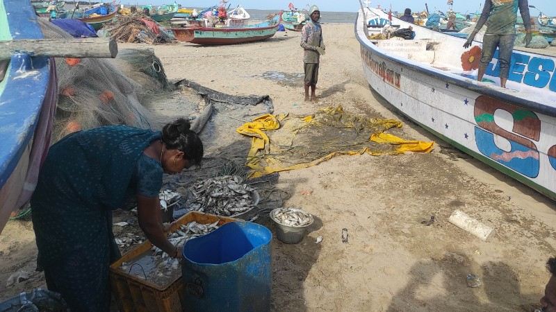
Figure 1: Women cleaning “Kothuva” fish, while fishermen are cleaning their boat and net after removing fishes from the net. Photo taken by the author at Vellapallam village, Nagapattinam district. Image captured by author.
This region is part of the Kaveri Delta coasts as shown in Figure 2 where the Kaveri River and its distributaries drain into the Bay of Bengal to its east, and the Palk Bay to its south. The Palk Bay is a shallow bay between the landmasses of India and northern Sri Lanka with a gentle slope from west to east[1], while the Bay of Bengal is really an open sea (also see Figure 3).
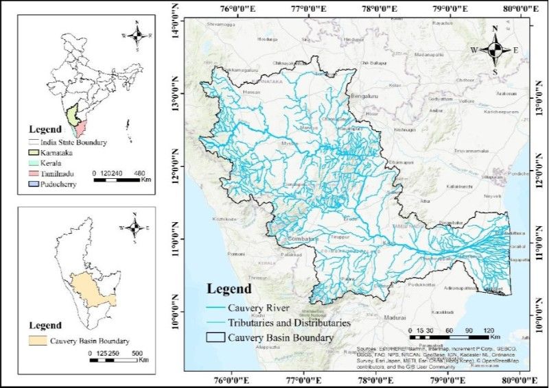
Figure 2: The dense distributaries that makeup the Kaveri delta system, Cauvery River Basin Atlas, 2024, National River Conservation Directorate, Ministry of Jal Shakti, Government of India, 2024. Accessed at https://cganga.org/wp-content/uploads/2025/10/Cauvery_River-Atlas_151025.pdf. Allowed to re-print as per copyright policy, hyperlinked here.
Silt is the fine-grained soil, sediment and mineral particles drawn up by rivers through their course. The Kaveri delta itself is a geologic product of this metabolism of silt and water. On the coast, it is the nutrient rich silt deposits that make the most fertile fishing grounds round the year – shaping the livelihoods and histories of fishers.
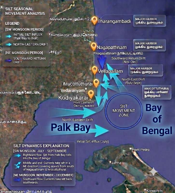
Figure 3: Silt flows in the Kaveri Delta coasts. Infographic prepared by the author, based on field interviews, using Google Earth base map, and AI tools. Map data from Google.
Based on field interviews, it was learnt that the annual Southwest monsoon sees increased discharge of silt from the Kaveri river system, especially on its southern distributaries onto the Palk Bay. Due to its slope, the nutrient rich silt rolls along the Palk Bay eastward flowing into the Bay of Bengal. This zone is where most of the region’s fish are also caught – including the ones being cleaned in Figure 1. In July-September, the northward longshore currents make the silt travel in a northwest direction towards the coast. In November-December, the Northeast monsoon with its north to south longshore current remove the silt from these coasts towards Palk Bay again.
There are also frequent cyclones with storm surges during November-December making this “flow” of slit turbulent and unpredictable. In 2018, the cyclone Gaja that hit the region was accompanied by devastating storm surges that pushed the clayey silt from the seabed to almost 1.5 kms inland, wreaking havoc in places to the south of Vellapallam (although the storm surge itself was less deadly in Vellapallam itself).
To keep this silt away from Vellapallam and ensure larger boats have secure docking, the State Fisheries Department, in its infinite wisdom, approved building a fisheries harbour with two breakwaters. Once construction began in 2021, boulders being laid for the breakwaters started to sink in the clayey seabed. It was halted with hardly 30% of the breakwater completed. This spectacular failure of the harbour project is not only a matter of corruption, or an underestimation of this silt cycle, but also points to its unpredictability. Engineering may be conceived as a solution to siltation but this very silt is itself a challenge to engineering.
Silt as an Agent of History
Nagapattinam was an important port town throughout the last millennia under the Cholas[2], under the Portuguese, under the Dutch, and later under the British East India Company from 1784. In this colonial period, silt was problematized as a barrier to functioning of important ports. Ports on the Kaveri delta weren’t seen as “naturally deep” harbours. At Nagapattinam, ships had to be anchored at 2 to 4 miles from the port. The Dutch had erected groynes at the mouth of the river (Figure 4), presumably to reduce siltation at the port entrance.

Figure 4: Depicting the ‘Crowded Negapatnam’ from 1680 as well as the river mouth groynes. ‘Negapatnam van Choromandel’, 18th century Dutch engraving of Nagapattinam after original engraving by Johannes Kip c. 1680. Accessed here . Image in public domain due to age.
The 1680 painting[3] clearly depicts smaller boats loading and offloading goods from larger ships anchored at a considerable distance from the shore due to insufficient docking draft. This led to a problematising of siltation in the Kaveri delta coast.
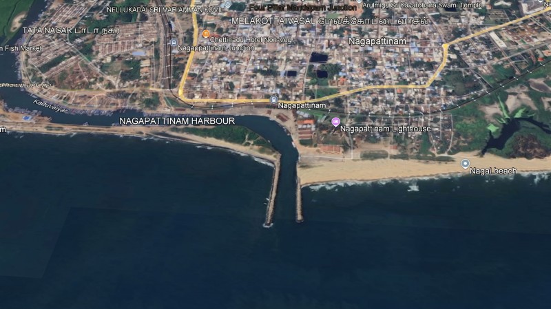
Figure 5: An aerial view of the image 4, at present, with the engineered river mouth. Screenshot by author. Map data from Google.
Wave-power and ‘erosion’
Meanwhile, Denmark secured the port of Tharangambadi (Tranquebar) in the north of Nagapattinam as part of the same Kaveri delta coasts, on long term lease from the Raja of Tanjore and built the Dansborg fort in 1620. Despite less siltation, the sea was intense here – the very name Tharangambadi alludes to the power of the waves. In 1752 and 1755, storm surges and cyclones during the Northeast monsoon caused the sea inundating a large part of land[4] next to the fort (Stephen 2023).
British interest in Tranquebar’s naturally closer anchorage points led to its takeover in 1845. This may also have been necessitated by the East India Company’s 1837 decision to shift to steamships and phase out all sail ships (Khalili 2020), meaning larger ships requiring deeper-draft ports. Silt thus becomes a “problem” necessitating not only engineering but also political solutions.
The British were clearly very well vested in Tranquebar making it their district headquarters and residence of the collector, shifting from Nagapattinam. In 1846, they commissioned navigation canals from Tranquebar to the northern ports of Thirumulaivasal and beyond. But they too repeatedly faced the wrath of the sea. In 1849, another cyclone during the NE monsoon caused the sea to erode over 2 yards of coastal land. In 1853, the Customs House was damaged in a cyclone. The Madras Engineers Report of 1856 mentions several groynes and seawalls already built by the Danes to protect the Dansborg Fort. A British report from 1853 quotes that, about hundred years earlier, the shoreline was 500 feet beyond the present sea wall. The British also made several additions to the groynes at Tranquebar in 1859.
The colonial administrators felt this continuous denudation of the coast, which was not called erosion yet – was most striking in Tranquebar. So much so that the 1907 Tanjore district gazette emphatically claims that there are no deltas being formed on the coast, meaning the coastal silt and sand are instead being chipped away by the strong Coromandel currents with no more silt and sand coming in to replace it. This “lack of silt” is problematised through the contra-discourse of continuous erosion, as opposed to siltation.
It appears the British had made up their minds to leave Tranquebar after repeated failures of various coastal engineering structures. The following year in 1860, the Nagapattinam railway line begins to be laid, and the railway station becomes functional by 1861, barely 5 years since railways began in Madras Presidency showing the importance of this region to the Presidency. These developments brought Nagapattinam back into prominence.
Engineering the coast
We again see the same twin forces of silt vs sea at play in Nagapattinam. With the British refocusing here, dredging emerged as a key function of the port – both with new steam-based as well as manual dredgers. A new port officer was designated for dredging duties (Seeralan 1987) and various technical committees were appointed for permanently deepening the bed of the river channels leading to the Port. In 1870, the Vedaranyam canal is built connecting the Salt Pans nearby Palk bay coasts[5] to Nagapattinam – serving twin purposes of cheap transport of salt to Nagapattinam for trade, as well as deepening the river channels slightly upstream of the Port. A permanent wharf was constructed from some of the dredged sand in the 1870s. But dredging was repeatedly claimed as costly [6].
Equally, the cyclone of 1862 damaged the extended river mouth groynes, and the British were able to repair them only by 1865. In 1909, experimental groynes erected at a distance from the river mouth were destroyed and washed away further south during the North East monsoon – which the Port Officer describes as, “It will be seen by the above that these exposed groynes cannot withstand the fury of the northeast monsoon, and any expenditure on this account will be a waste of money” [7].
By the turn of the 20th century the port’s shallow draft and siltation led to the diminished importance of Nagapattinam compared to the emergence of deep-water ports like Tuticorin port, further south in the Gulf of Mannar, opened in 1876 and connected by railway to Madras – thereby taking over the Ceylon trade.
Thus, a problematisation of siltation becomes a central theme in colonial discourse – which is contingent on political, economic and technological changes. The history of these Kaveri Delta coasts cannot be written without alluding to the crucial role played by Silt – truly an agent of history!
Post-Independence continuum
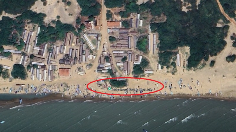
Figure 6: No T-Jetty or dock-like structure visible on site, nor on this Google Earth image from 2024. Screenshot captured by author. Map data from Google.
In the Palk Bay coast of the Kaveri Delta lies Kodiyakarai. With no visible trace of any harbour at present day, it was only in the archives that I had discovered that a fisheries harbour – T-Jetty was constructed there during the 6th five-year plan in 1977.
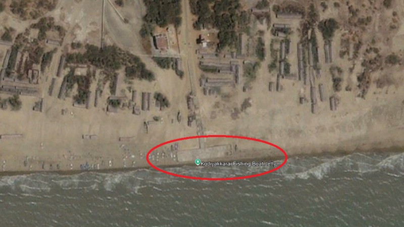
Figure 7: Google Earth image from 2002 showing vague outlines of a T-Jetty already subsumed by the sand and silt. Screenshot captured by author. Map data from Google.
Google Satellite images from 2002 show that indeed, such a T-Jetty harbour was essentially swallowed up by the sheer volume of silt emanating from the southern distributaries of the Kaveri delta, confirming the metabolic cycle of silt as elaborated by fishers.
The last 10 years have witnessed demands for several harbours and breakwaters across this region– with new ones being constructed at Tharangambadi, Nambiyar Nagar (in Nagapattinam town), Vellapallam, and Arcottuthurai (close to Kodiyakarai). The demand in Tharangambadi was due to erosion and seawalls, with no more space for beach landing crafts. The demand in Vellapallam was based on preventing the annual upwelling to the shore of silt and mud. But the breakwater construction at Arcottuthurai hasn’t prevented siltation within the harbour site and has caused furious buildup of silt south of the breakwater, while the breakwater boulders at Vellapallam are sinking.
This brief history of “siltation” and coastal engineering along the Kaveri delta coast warrants epistemic analysis. As a start – the Tamizh word for any shore is ‘Karai’ – riverbank, seashore, etc – the coast becomes Kadarkarai[8]. But as a verb, Karai also means to dissolve. I speculate that Karai is philosophically conceived as the place of the continuous dissolution of land and water – a place always in the making and becoming. Coastal engineering, however, runs on the opposite logic of making solid land – to tame the silt, having clear separation of land and water. This is to meet many maritime and fishing requirements no doubt, but its conception of rigidity is at odds with turbulent fluidity. Thus, silt is central actor in continuously making the coasts, not just physically but also by shaping discourse, politics and livelihoods.
Acknowledgements
This post was curated by Contributing Editor Misria Shaik Ali and reviewed by Contributing Editor Tiên-Dung Hà.
Notes
[1] The whole of Tamilnadu, India’s south eastern regions have a gentle west to east slope. This is why most rivers draining onto the east coast. This is why the delta has a lower elevation than most other geographies in India. This slope continues after the coasts, in the nearshore seabed as well.
[2] Although Nagapattinam was historically known as the chief port and thriving coastal city of the Chola empire in medieval times, there is little evidence of coastal engineering structures.
[3] The painting also depicts vibrant fishing activities on similarly sized crafts alongside these lighterage services – perhaps hinting at today’s so-called fishing communities may have been active participants in multiple marine-based activities.
[4] The Danish applied to the Tanjore Raja for an extension in territory to compensate the loss. The denial by the Raja led to a military skirmish between Tanjore and Tranquebar and the British Madras Governor had to personally intervene.
[5] These are among the most famous salt production zones in India. It was also where the famous Vedaranyam Salt Satyagraha, protests against the colonial Salt Tax was held in 1930.
[6] Tanjore District Manuel, 1883, by Venkataswamy. Accessed at Tamil Nadu State Archives.
[7] Report of British Port Officer in 1910 – No.358, dated 28th November 1910. Accessed at the Tamilnadu State Archives.
[8] In Tamizh, Kadal is the sea, so the seashore becomes Kadarkarai.
Bibliography
Khalili, Laleh. 2020. Sinews of War and Trade: Shipping and Capitalism in the Arabian Peninsula. Verso.
Seeralan, N. 1987. ‘A Survey in the Ports and Harbours of the Madras Presidency (1858 – 1900)’. Bharathiar University. Tamil Nadu State Archives.
Stephen, S. Jeyaseela. 2023. History of the Climate Change on the Coromandel Coast: Ninth–Nineteenth Centuries. 1st edn. Routledge. https://doi.org/10.4324/9781003405078.

